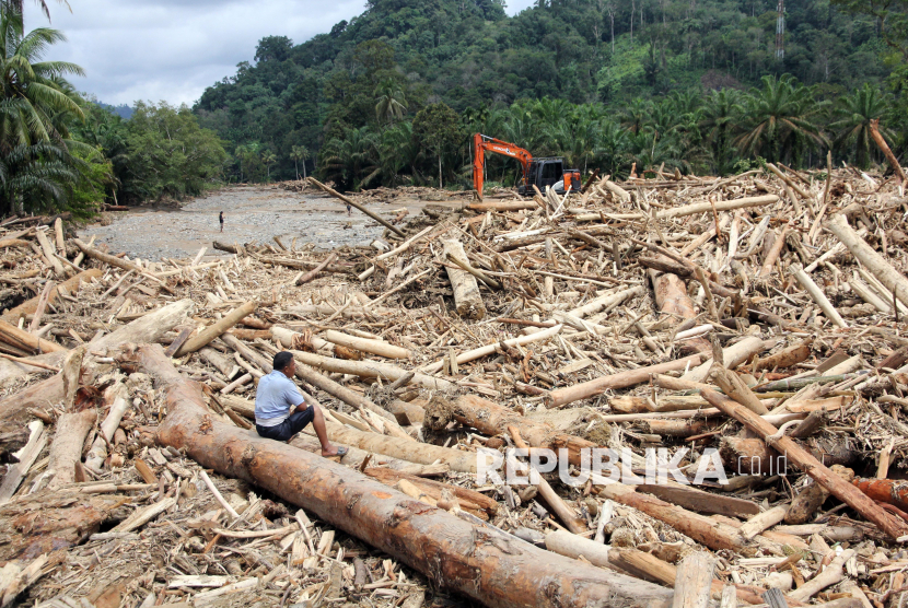
TEMPO.CO, Jakarta — The extensive flash floods and landslides that struck northern Sumatra following Tropical Cyclone Senyar should serve as a stark warning of severe ecological degradation across the island, environmental groups said.
Much of the damage occurred in river basins, hillsides, and other vulnerable landscapes that have lost their natural protections.
“The environmental carrying capacity of Sumatra is now critically endangered. Its forests have been heavily impacted and fragmented by thousands of extractive industry permits,” said Leonard Simanjuntak, Country Director of Greenpeace Indonesia, in a statement issued by the Coalition for Justice for Our Planet (JustCOP) on Monday, December 1, 2025.
Leonard added that climate anomalies linked to extreme warming in the Malacca Strait, such as the formation of Tropical Cyclone Senyar, demonstrate that the climate crisis is no longer theoretical.
“This disaster reminds us that nature has its limits. The impacts of environmental damage are cascading across communities, deepening social and ecological vulnerabilities,” he said.
Satya Bumi Executive Director Andi Muttaqien shared a similar view, stressing that the recent flash floods in West Sumatra, North Sumatra, and Aceh could have been significantly reduced if both companies and the government had conducted a thorough, transparent review of permits, development projects, and forest clearing.
“The high number of casualties must push the government to restore damaged ecosystems and re-evaluate permits granted to environmentally destructive companies,” Andi said.
According to the National Disaster Management Agency (BNPB), at least 442 people have died and 402 remain missing as of Sunday, November 30, 2025. North Sumatra has been the hardest hit, especially the districts of Tapanuli Tengah, Tapanuli Selatan, Tapanuli Utara, and the city of Sibolga.
The Tapanuli region is home to the Batang Toru ecosystem, also known locally as Harangan Tapanuli, an area of high biodiversity.
That landscape is now ringed by major extractive projects, including the Martabe gold mine operated by PT Agincourt Resources, the Batang Toru Hydroelectric Power Plant, the Pahae Julu Micro Hydropower Plant, geothermal operations by PT SOL, the pulp producer PT Toba Pulp Lestari, and large-scale oil palm plantations owned by PT Sago Nauli and PTPN III Batang Toru.
Data from Satya Bumi shows that PT Agincourt Resources holds a concession covering 130,252 hectares, of which 40,890 hectares overlap with the Batang Toru ecosystem, habitat of the critically endangered Tapanuli orangutan.
Another 30,630 hectares overlap with protected forests in Tapanuli Utara, Tapanuli Tengah, and Tapanuli Selatan.
Agincourt has already cleared 603 hectares of its concession as of October 2025. Andi said the company plans to clear another 195 hectares for a Tailing Management Facility (TMF) in the upstream area of the Nabirong watershed, raising concerns that contamination could spread into the Batang Toru watershed. The fact that the Martabe mine sits in an area with high seismic activity has heightened fears.
Satya Bumi is urging a full audit of extractive activities across the Batang Toru landscape, including Agincourt’s mining operations and the Batang Toru Hydroelectric Power Plant.
“It is time for the government to take firm action against companies proven to be destroying forests and to halt new permits that increase pressure on the ecosystem,” Andi said.
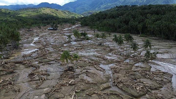
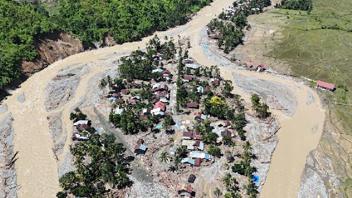
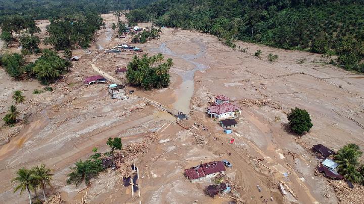 Residential areas affected by flash floods in Aek Garoga Village, Batang Toru District, South Tapanuli Regency, North Sumatra, November 29, 2025. Antara/Yudi Manar
Satellite analysis conducted by the Indonesia's Mining Advocacy Network (Jatam) using the Nusantara Atlas suggests that Agincourt’s activities have caused 739 hectares of deforestation over the past year.
Oil palm expansion is adding further strain by degrading soil structure, contributing to erosion, and undermining river hydrology.
Statistics from BPS show that around 10 million hectares of oil palm plantations, many overlapping with mining zones, have transformed areas that once served as natural water buffers into mining sites, transport corridors, and settlements.
Forest concessions (HPH) and industrial forest plantations (HTI), which have been consolidated under the Omnibus Law into Business Permits for Forest Utilization (PBPH), also play a significant role in deforestation. These permits have altered forest functions and weakened the capacity of watersheds to naturally slow water flow.
The deterioration of Sumatra’s watersheds has been further accelerated by the permit mechanism for forest area utilization (PPKH), which has allowed protected forests to be converted into extraction zones.
Editor’s Choice: Home Affairs Minister Admits Government Was Unprepared for Sumatra Floods
Click here to get the latest news updates from Tempo on Google News